Case Study
GEO ID — A Spatial Learning Experience Through Interactive Geography
GEO ID is a self-initiated geography game that explores how spatial context, interactive exploration, and nostalgic interface design can create a more engaging learning experience.
I designed and developed GEO ID after watching friends play geography games such as Worldle and noticing a recurring frustration: while existing games effectively test memorization, they often remove the geographic context that makes learning geography intuitive and enjoyable. Throughout the process, I leveraged AI to accelerate research, explore interaction patterns, and rapidly iterate on concepts, allowing me to spend more time refining the user experience.
Don't just read about GEOID, try it. The live game is embedded below, so feel free to explore the globe, make guesses, use hints, and experience the interaction firsthand.
Live demo: The real GEO ID game, fully playable. Rotate the globe, type your guess, request hints, and build a streak right here on the page.
Role
Product Designer & Developer
Focus
Game UX, Spatial Interaction
Skills
UX Research, Interaction Design, Front-End
Overview
The goal of GEO ID was to create an experience that rewards exploration, encourages spatial reasoning, and transforms geography learning into an engaging and visually memorable experience.
The Opportunity
While observing friends play popular geography games, I noticed that many experiences present countries as isolated shapes or abstract puzzles. Although these games test recognition and memorization, they provide limited context about where countries exist in relation to neighboring nations, geographic features, or the world as a whole.
How might we create a geography game that prioritizes spatial understanding and exploration rather than memorization alone?
Project Goals
I set out to design and build a geography game that would:
- Encourage spatial reasoning and geographic exploration
- Provide contextual clues rather than isolated visual puzzles
- Reward knowledge while maintaining accessibility
- Create an engaging visual identity that encourages repeated play
- Balance challenge, discovery, and player confidence
Key Insight
Players don't necessarily struggle to recognize countries. They often struggle to understand where countries exist in relation to the rest of the world.
Providing geographic context transforms the experience from a memorization exercise into an exploration and spatial reasoning challenge.
Solution
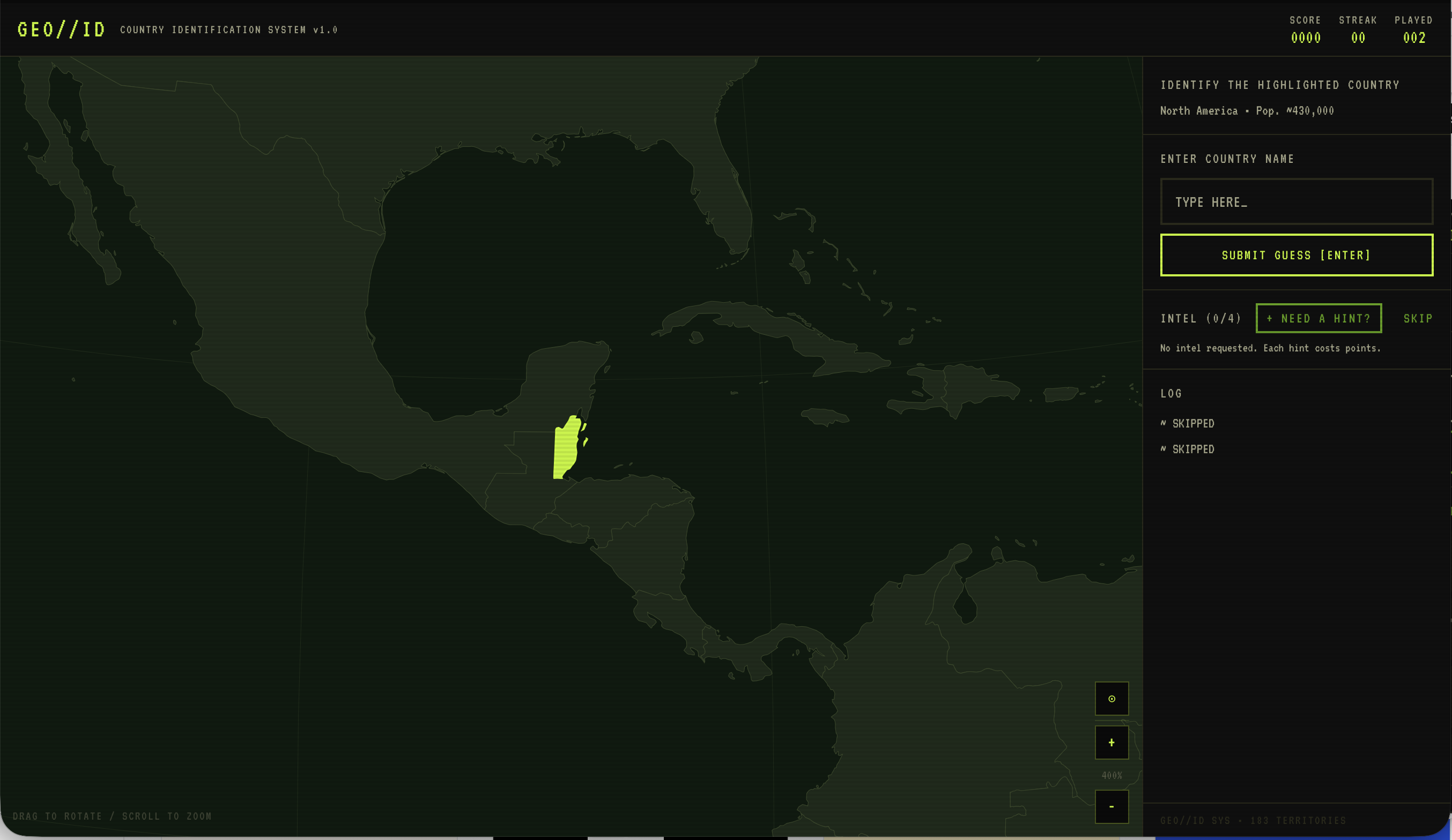
I designed GEO ID around the concept of progressive geographic discovery. Rather than presenting players with isolated country outlines, GEO ID lets players interact with a fully explorable 3D globe, providing geographic context and encouraging active exploration.
Players can:
- Rotate and explore a fully interactive globe
- Zoom and pan to investigate regions
- Submit guesses at any point
- Request progressively revealing hints
- Skip difficult countries
- Reveal answers when necessary
- Build streaks through consecutive correct answers
Progressive Hint System
To balance challenge and accessibility, I designed a progressive hint system that reveals increasingly specific information while reducing the player's final score.
| Hints Used | Score Awarded |
|---|---|
| 0 hints | 30 points |
| 1 hint | 22 points |
| 2 hints | 14 points |
| 3+ hints | 10 points |
Hint categories include:
Region & Location
Example: “Landlocked nation in South-Central Asia”
Neighboring Countries
Example: “Bordered by Pakistan, Iran, and Turkmenistan”
Geographic Features
Mountains, rivers, deserts, coastlines, and natural landmarks
Trivia & Historical Facts
Economy, history, records, and cultural information
This approach rewards existing knowledge while ensuring players never become permanently stuck.
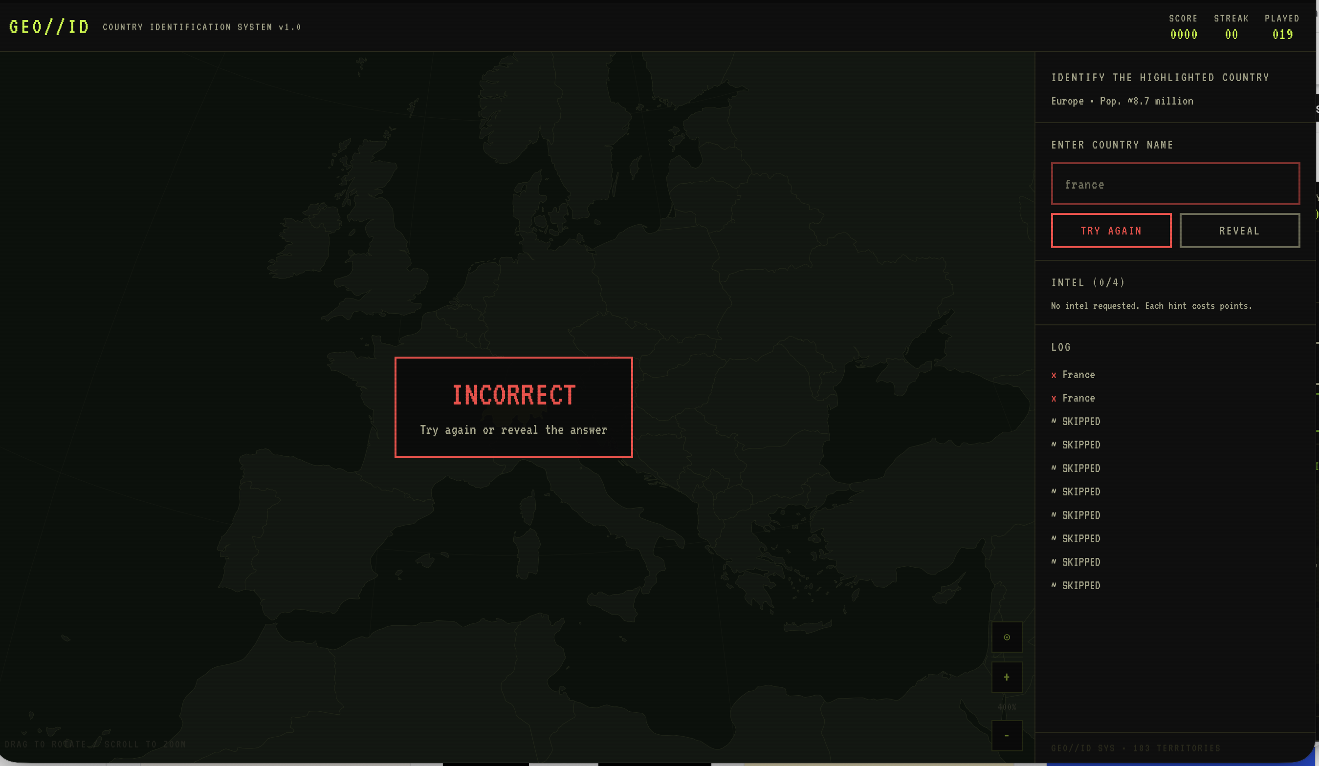
Visual Design
The visual identity of GEO ID was inspired by 1990s digital interfaces, early educational software, and retro computer aesthetics. The interface combines:
- Dark monochromatic backgrounds
- Glowing green geographic highlights
- CRT-inspired visual treatments
- Minimal UI elements
- Futuristic cartographic visualization
The goal was to create an experience that felt nostalgic, playful, and immersive, making learning feel less like a task and more like exploration.
Design Challenges
Designing an Intuitive Globe Experience
The most significant challenge was designing a globe interaction model that felt natural across desktop and handheld devices. Users needed to be able to:
- Rotate the globe intuitively
- Zoom efficiently
- Explore countries without becoming disoriented
- Maintain geographic context during interaction
Supporting Small Countries on Mobile
Another challenge involved ensuring that smaller countries remained visible and discoverable on handheld devices. To address this, I explored interaction patterns that balanced geographic accuracy with usability, allowing players to successfully discover and select smaller regions without creating visual clutter.
Design Principles
Spatial Context
Countries should be understood within their geographic environment rather than as isolated shapes.
Progressive Discovery
Information should be revealed gradually to preserve challenge while supporting learning.
Emotional Design
Visual identity and aesthetics should create an experience users want to return to.
Accessible Challenge
Players should feel challenged without feeling punished or stuck.
Outcome
GEO ID successfully combines:
- Spatial learning
- Interactive exploration
- Progressive game mechanics
- Nostalgic visual design
- Educational discovery
The project demonstrates how interaction design, game mechanics, and visual storytelling can work together to create learning experiences that are both engaging and memorable.
Reflection
This project reinforced the importance of designing around how people naturally build mental models rather than simply testing memorization. What began as an exploration of geography games evolved into a broader investigation of spatial cognition, interaction design, and emotional engagement.
By combining contextual learning, progressive disclosure, and nostalgic visual design, GEO ID became an experiment in how educational experiences can feel playful, rewarding, and deeply engaging.
Want to see more of my work?
View All Projects